| |
Process
Trying to find the edge of a world is a great quest. “The whole world speaks” says the Oregon poet, William Stafford. But, how does it speak to us? And, how do boundaries articulate differences?
Discerning boundaries which “speak” to us within a border or edge is a profound adventure, bordering on that mysterious region where science and poetry and prayer converge.
Maps are useful, of course, as are wonderful new satellite imagery. But these remain merely mute guides, especially when you’re trying to create a map that may have never existed before. You have to literally “go there,” see for yourself, explore the body of this world, and then “study up.”
When you do go to the edge, say standing on a mountain or sitting on the sand of a beach, it’s surprising to find that there are no boundaries there “on the ground.” The world just goes about its business, flowing by continuously, unconcerned about our need for boundary-making. Even so-called “natural boundaries” on ridgelines, for instance, are not obvious among the welter of peaks and slopes—it’s often hard to tell where the drainage divide runs from “here to there” from ridge to ridge.
The problem is exacerbated, of course, when dealing with wholly artificial political boundaries as “lines on a map” such as the 49th parallel which forms the western boundary between Canada and the United States, or the epitome of strangeness, that intersection of the straight-lined “Four Corners” region in the American southwest.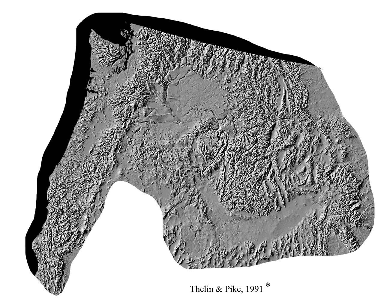
Again, passing over the crest of the Rockies, as the trees give way to scrub and then open grassland, you know you’ve entered a borderland, but because the transition is gradual, there’s again no obvious boundary there. Indeed, that is part of the difference between borders and boundaries.
So, the first task is to explore the borders of your bioregion. There are several steps in this process.
First, you need to discover the essential character of your place, as shown here. Curiousity leads naturally into continuous probing of edges--”poking down this path,” then another, “to see where they go,” to “find out where you end up.” There are always centers and bounds composing any place, and since we usually start in the centers, we proceed out into the body of the land through settlements, watersheds, and ecoregions, edge by edge, to discover where things shift in the borderlands.
In this exploration of Cascadia, we began with the land and looked into its dynamisms, shape, location, size, face, lineation, etc., and only now do we turn to the question of boundaries. If you don’t know the character of your place, how then will you recognize when it changes?
In the process of discovering and “mapping your bioregion,” it is important to go through the preceding steps to clarify and ground your vision in a distinct apprehension of the characteristic regime of your land before attempting a final definition of boundaries. If, on the contrary, you begin with a declaration of boundaries, then the “inside” becomes a empty container to be filled up with biases and projections. Besides, if you’re clear about its character, you know what you’re “on the lookout for,” and may then be open to surprise when you find something else…!
Boundary discernment is an on-going process of discovery, a wonderful way to get to know the wider world better. We pass from consideration of internal character to the external context through the threshold of boundaries. Boundaries are essential to articulation of place. Inside-threshold-outside.
Second, the next step includes not only continuous probing of edges but launching yourself into the borderland beyond your region. Go past where you think your bioregion may end, enter another world, and then look back home.
Remember when the traveler passing over a sub-regional divide like Snoqualmie Pass on I-90 east of Seattle was advised to “Keep Going—Don’t Stop! Proceed all the way over to the other side of the other side.” That is, leave home and wander into the borderland.
Driving east on this trajectory means that eventually you’ll pass over the High Rockies down into eastern Montana. If you were born in Washington or Oregon and have never been there, you’re in for a shock. I took our children there once to explore and camp. But the vast open treeless space was so foreign to their tender sensibilities they refused to stay, and demanded we go back westward, return to the familiar shelter of forests and mountains. Only camping by a mountain lake mollified their sense of what was “natural and right” in the world, and set them again at ease.
In the present process, having discovered the character of Cascadia in terms of its alternating rhythm of windward and leeward sides, when you run out of “westsides and eastsides,” then you know you’ve entered another country. Far out on the High Northern Plains you can drive hundreds of miles and it stays the same, mile after mile. Everything distinctive about Cascadia vanishes into the whistling wind.
A similar transition occurs when you ride down I-5 through the magnificent looming portal of Mt. Shasta (source of the Sacramento River), and follow it down the long sloping ramp of the Klamath Mountains through Redding and Red Bluff and Chico into the Great Valley of California. Everything’s different--the landscape in the long flat open valley and the rolling golden hills dotted with oaks, the warm weather and dry climate, the quality and intensity of the light, even the colors and aromas are different. Perhaps its the Bay trees or the Eucalyptus trees mixed with the dry dust, but California has its own scent. When you encounter the olive groves at Corning, and the endless orchards and field crops and flooded green rice fields at Williams, then you know you’ve entered another world.
A similar transition becomes readily apparent when you fly to Salt Lake City from Seattle, for instance—you know instantly you’ve entered into a contrasting world—physically, culturally, spiritually.
Thus, if you launch yourself into the borderlands beyond the portals of Cascadia, and look both ways—into the new land and back toward Cascadia--you know they represent different worlds.
The borderland involves this recognizable transitional area. A border is an edge or margin, a strip alongside the place that frames and encloses it, where different countries touch.
Third, a basic way to begin to discern boundaries in complex terrain is to “stitch the edge.” In the borderland you move back and forth in a deliberate fashion progressing around the edge of the edge, trying to discern those “turnings in the earth” where the worlds on each side begin and end. Weavers and quilters call this edge, the “selvage,” where the woven threads running back and forth turn on themselves, so that it literally forms a “self-edge.” Finding the boundary, then, is like forming a “selvage” on the edge of the raveling fabric.
In short, as preliminary steps in discerning the boundaries of your bioregion, first learn to recognize its internal character, second, leap beyond its edge into the borderland and look back, and third, dwell within the margin, carefully binding the border by “stitching the selvage.”
Borders & Boundaries
But the border is not a boundary. Though we often equate borders and boundaries, they are not the same.
Borders are found everywhere in nature, but boundaries are not. You can see a border, but you have to think a boundary. A border is a margin, or side, while a boundary is a defining line. A border is a transitional edge or margin surrounding (literally “bordering”) a land, while a boundary is a limit line located within the border (literally, “bounding” this side from that). Though often conflated, boundary and border have different natures and functions.
There is so much confusion surrounding the nature of boundaries we can only scratch the surface here. It is not a question, for instance, of “good” borders vs. “bad” boundaries, nor of “soft borders” substituting for “hard boundaries,” nor even the chimera of a “borderless world” in economic theology. A “borderless world” is a globular world, everything melted into one, a pawn of global corporations and media.
Further, since there are no intrinsic boundaries in nature, it is beside the point to bemoan boundaries as “artificial constructs,” for by their very nature boundaries are humanly created. Borders are physical, boundaries, representational. Boundaries are inherently normative and symbolic.
If, one day, for instance, all the tired old boundaries in the world were erased, new ones would surely spring back the next day. It seems we simply cannot live without making boundaries. Since borders are always “contested terrain,” we create boundaries to divide sides and contain conflict, and limit purview, as well as our central concern here--namely, articulating the land’s turnings. Further, there are borders without boundaries, and boundaries without borders (which become highly problematic). The thorny thicket emerges….
In brief, borders are physical areas found in nature, functioning as a meeting ground, edge terrain, or transitional margin, which you can live in and move through; thus, they are perceptible. But you can’t see a boundary on the ground, only imagine its transit. Nor can you dwell within a boundary, but only cross through it, like passing over a threshold in a door opening both ways. Indeed, the boundary line in law has no thickness! Again, the border is the margin surrounding the sides, while the boundary is a limit line inscribed within the border. Border is to side as boundary is to limit....
Natural Boundaries
All well and good, perhaps you might say, but still—as you stitch the edge, what to look for? Articulation of boundaries involves discerning a difference that makes a difference. In discovering potential boundaries, we look for changes, beginnings and ends--shifts in landforms, the lineation and lay of the land, faults, rock types, soil types, vegetation and biotic shifts, ratios of this complex to that, climate zones, etc. Indeed, there are countless single-factors to consider as key indicators of changes in the land. From a bioregional perspective, we are looking for where these layers converge. We are looking for shifts in central type and regime (not stragglers or “outliers”).
Constellation of these factors becomes the key to discerning boundaries as defining limits of the land. However, discernment of the different layers of life of the land and how they converge, especially in a dense landscape like Cascadia, can become soon overwhelming in its complexity.
No wonder people have traditionally have sought out so-called “natural boundaries.” Though they must be found and not declared by fiat, boundaries as limit lines need visible expression. That is why traditionally physical features such as mountain ranges and rivers and oceans have served as convenient, visible, dividing lines. Strictly speaking, there are no boundaries in nature, so even these natural features must be endowed with significance to serve the symbolic function of “boundaries.”
A mountain range, for instance, is unusual in that it already functions as a drainage divide. It demarcates one side from another. The mountain-as-divide performs the function of a normative boundary insofar as it already separates the land into sides, and apportions the flow to each. A happy convergence occurs here, as the physical feature has both practical and symbolic significance at the same time.
In addition, a rugged mountain range serves as an obstacle to passage. You have to “cross that boundary,” making a special effort to “go over there” across the peaks or raging river. Physical isolation and hardship prevents easy passage, and reinforces the sense of natural boundedness.
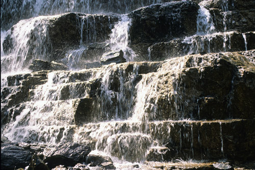
Now, in bioregional work, watersheds and drainage divides take on additional significance. For these provide a useful first approximation to living boundaries. Watersheds, of course, articulate which way the waters flow, which direction the river runs—upriver/downriver--for the current is a primal fact of life in a place, like a tide that never ebbs. Watersheds gather the waters, and direct the flow down gradients, as they course through the veins giving life to body of the land. In a watershed, 99% of the water is in the shed, only 1% in the streambed at any one time. Indeed, rivers are the visible sign of the crossing of this earth and that sky in the endless life-giving “water-cycle,” which was once seen as the signature of the “wisdom of God.”
Watersheds as Ecosystems
But there’s more. For in the bioregional work which has built the notion of Cascadia,watersheds take on special significance as “proxies” for ecosystems. Recall that “an ecosystem is a concept, not a percept,” as Tom Jay says.
 You can’t simply walk out into the woods and see the functioning of an ecosystem in its intricate flows and cycles. A related perennial problem is that ecosystems have no inherent boundaries. You can’t simply walk out into the woods and see the functioning of an ecosystem in its intricate flows and cycles. A related perennial problem is that ecosystems have no inherent boundaries.
Hence, an ecosystem needs to be specified, located, tied to recognizable features on the ground. Here, again, a watershed serves as a convenient way to visibly bound an ecosystem on a landscape level. As Eugene Odum, father of “Ecosystem Ecology,” proposed (following the classic experiments of Borman and Likens), a “watershed is the closest practical natural approximation to an ecosystem.”
Hence, we use drainage divides here as a visible, convenient, symbolic representative of ecosystems for a first approximation of bioregional boundaries.
Delineation of the Boundaries of Cascadia
Coming Later
back to where you were reading
home page |
|